Being a cloudy cold day, we didn't feel up to much, so we headed to Button Rock Preserve and started hiking at 11:48.
You can see the GPS tracks for this entire hike.
We went up the gravel Dam Road, then left on the Sleepy Lion Trail. At the first big meadow, we went off trail, turning left up the hill and through the meadow, then topped out on a wooded knob, then through another meadow.
We soon crossed over the trail that leads to Hall Ranch, and continued going in a southwest direction until we hit an old road, which we turned right onto.
This road eventually led to a gate with a sign on it indicating the boundary of Button Rock Preserve. After this gate, the road becomes the Sleepy Lion Trail which we took to the bottom of the next gulch.
From there, we went off trail again, crossed over the gulch, and headed southwest up the steep slope along a deer trail to the top of the next knob.

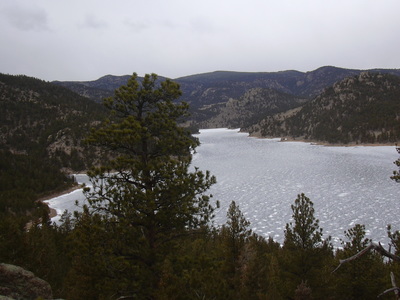
2013-02-10 Button Rock (Ralph Price) Reservoir from knob south of dam
We stopped for lunch on the northwest side of the knob, in a natural rock windbreak with an amazing view of Button Rock (Ralph Price) Reservoir, which was quite frozen. From there we could see down the entire length of the reservoir. After lunch, we headed northwest, down the slope to the reservoir where we took the fisherman's shore trail to the dam.
Crossing over the dam, we turned left onto the gravel road which follows the shore. At the spillway, we took the dirt road down to the Dam Road, then back to the start. We finished at 14:39, with the GPS odometer at 4.6 miles.
| Place Name | Elev [ft] | Accuracy [ft] | Position (lat,lon) |
|---|---|---|---|
| Parking at Button Rock Preserve | 5,996 | 23 | 40.22868,-105.34161 |
© 2012-2013 Stefan Hollos and Richard Hollos
blog comments powered by Disqus