From Lyons, west on CO Hwy 7. Turned right about 1/2 mile after marker 22. Took first right after 300 ft, then 1.3 miles.
Parked a little up the road from the Dry St Vrain Trailhead. No one else here. After about 100 ft we leave the main trail and take a small trail to an unnamed lake.
After a while the trail becomes indistinct and we lose it. We see S Sheep Mtn summit and decide to head straight for it. Dropping down to the Dry St Vrain is very steep. Much devastation due to the flood. Canyon is very steep on both sides. The Dry St Vrain is not dry this time of year and it takes a while to find a place to cross.
After crossing we are faced with a rock wall. We find a way to scramble up to a rocky ridge. Following the ridge turns into forest and we find many deer trails. They all seem to head in the direction of a saddle not far from the summit so we follow them.

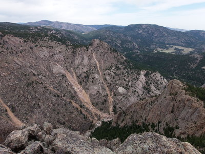
2014-04-26 North Sheep Mtn from South Sheep Mtn summit
We reach the summit area which is basically a large granite dome. Circling around we find a notch that leads to a shelf just below the summit rocks. A short scramble and we're on top. You can see everything from up here. The south slope of N Sheep Mtn has large scars from the flood. The N Sheep Mtn trail, about 2000 ft below has been obliterated by the flood.
On the way down we find an old miner's trail that takes us to the Dry St Vrain, far up from where we crossed. We cross and head up the ridge on the other side where we find the lake.

2014-04-26 Unnamed lake 7467
Some unusual ducks in the lake, a Common Merganser and some Lesser Scaups.
Eat lunch at the far end of the lake. The ducks stay as far away as possible. Surrounding ridges are reflected in the lake. Wind picks up along with a few rain drops. Take a much shorter route back to the truck.
Dry St Vrain Trail description at Forest service.
| Place Name | Elev [ft] | Accuracy [ft] | Position (lat,lon) |
|---|---|---|---|
| Parking off Conifer Hill Road | 7628 | 16 | 40.18126,-105.41318 |
| South Sheep Mtn summit | 8342 | 26 | 40.20887,-105.42617 |
| Unnamed lake 7467 | 7526 | 16 | 40.19650,-105.41716 |
© 2012-2014 Stefan Hollos and Richard Hollos
Tweet

blog comments powered by Disqus