Audubon Glacial Bowl, 10/03/2009
The whole Audubon glacial bowl, 10-03-09
Starting from the Mitchell Lake Trailhead at 9:15, we hiked to Mitchell Lake, then went clockwise around the lake to its north side. We ascended a steep talus slope, following along a strip of krummholz where the ground is more stable. The krummholz soon gave way to alpine meadow, and a grand view of the lower end of Audubon's glacial bowl.
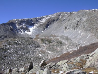
Ascending along the former path of the ancient glacier, we continued up until the last patch of alpine meadow. There we sat down on a large glacial erratic at 11,868 feet and enjoyed the view. Overhead to the west, is the impressive glacial headwall marked by narrow rock terraces. To the south is the remnant of the glacier that once filled this huge bowl. And to the east, one can see the huge scale of the path the glacier carved out on its way to what is now Mitchell Lake. As the sun was loosening up some of the ice on the headwall, we occassionally heard debris bouncing down the wall. To the northwest there appears to be a reasonable way to Audubon's summit, at about the same level of difficulty as the way from Indigo Pond to the Divide.
On our way out, we headed east, then northeast out of the bowl near a large patch of willows. Continuing northeast across the tundra, we intercepted the Mount Audubon Trail, then took the trail back to the Mitchell Lake Trailhead, returning at 14:50.
- Richard Hollos and Stefan Hollos
| Place name | Elev [ft] | Accuracy [ft] | Lat/Lon |
|---|---|---|---|
| Mitchell Lake Trailhead | 10522 | 6 | 40.08348,-105.58130 |
| Our high point in bowl | 11868 | 9 | 40.09607,-105.60728 |