Point 7985 and Cook Mtn from Coulson Gulch, 11/07/2009
North St Vrain Canyon from Cook Mtn, 11-07-09
Off the Big Elk Meadows road (Larimer CR 47), we parked at the Coulson Gulch Trailhead just past the open gate to the national forest.
We started hiking at 9:47, heading east and southeast along a 4WD road as it circled clockwise around Point 7985. The last stretch was a steep single track closed motorbike trail that extends almost to the summit. We reached the top of Point 7985 at 10:15, with the odometer at 1.63 miles. It was an unnaturally warm day for early November on the summit and the views were spectacular. Kenny Mountain, Longs Peak, and Button Rock Mountain could all be seen.
From the summit of Point 7985, we descended the south ridge, which parallels the Coulson Gulch Trail. This ridge has rugged terrain in places, but also stretches of easy traveling.
We finally made it to the saddle between Point 7985 and Cook Mountain, which is an open meadow at Higgins Park. From there we followed a dirt road up the north ridge of Cook Mountain, which eventually turns into a deer trail, then vanishes altogether before the summit.
The summit is the northern of the 3 knobs. On our previous ascent, we mistakenly thought the middle knob was the summit, but the northern knob has a summit register, as well as a summit nail placed there by a Longmont surveying crew many years ago.
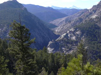
We reached the Cook summit at about 12:20 with the odometer at 5.42 miles. From the Cook Mountain summit are great views of North Sheep Mtn, North St Vrain Canyon, and what we call Bubbies Pickles Peak (Point 8547) from the jar containing the summit register that Mike Garratt placed there long ago.
But the most interesting part of the summit is the 35 year old register enclosed in an old goat's milk container. The record shows that Bob Michael of Table Mesa Drive in Boulder placed it there on March 16, 1974. The next year (1975) there was a signing by Barb and Gerry Roach. For the 10 years from 1979 to 1989 there were no signings. Then Mike Garratt signed it in 1989, and wrote "Will it be 10 more years before someone else signs this register?". The next guy signed it in 1992, and wrote "No Mike, not 10 years, but 3." A guy that signed it in 2000 commented that the register is as old as him. Large gaps in the signing were 10 years, 3 years, then 8. Ranger Dennis was there in 2001 who said he saw a deer, an elk, and something grunted at him from behind some bushes. Luke Plumely signed it Nov 4, 2007. Although there are several loose pages in the register, and the wire holding the pages together is very rusted, the register isn't close to being full, and might take another 35 years to reach that point.
After a rest and lunch on the summit, we descended the ridge the way we came, then at Higgins Park took the Coulson Gulch Trail back to our parking place.
We returned at 14:30 with the odometer at 9.11 miles.
- Richard Hollos and Stefan Hollos
| Place name | Elev [ft] | Accuracy [ft] | Lat/Lon |
|---|---|---|---|
| Coulson Gulch Trailhead | 7704 | 7 | 40.25031,-105.41054 |
| Point 7985 | 8020 | 11 | 40.24434,-105.40623 |
| Low Point btw Cook Mtn and 7985 | 7025 | 9 | |
| Cook Mtn summit | 7586 | 7 | 40.21795,-105.40467 |