Coulson Gulch - North St Vrain Canyon Loop, 03/21/2009
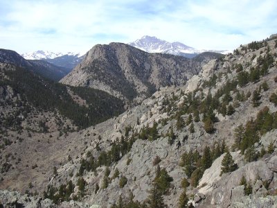
Deer Ridge with Mt Meeker (from elev 7903 ft, 40.21426,-105.44527), 03/21/09
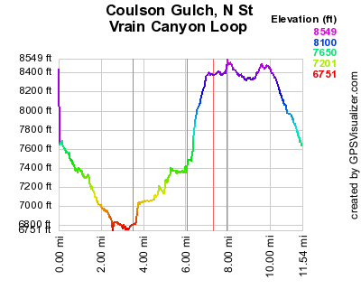
Elevation versus distance, 03/21/09
You can see the GPS tracks for this entire hike.
Off the Big Elk Meadows road, we parked alongside the dirt road to Coulson Gulch, at the closed gate just before the Coulson Gulch Trailhead.
We started hiking at 10:12, down the Coulson Gulch Trail. Descending approximately 900 feet to the intersection of the Coulson Gulch Trail and the North St Vrain Creek, we turned right, hiking up the trail that parallels the creek.
Hiking to the intersection with the North Sheep Mtn trail, we departed the trail, going west along an old mining road, parallel to the creek, and a couple hundred feet above it.
We followed the old mining road for about 1.5 miles until it seemed to fade away, then ascended northeast to a ridge, then north through lightly wooded forest until we hit the Bright Extension Trail. On our ascent, we caught a great view, at 7900 ft, of Deer Ridge and Mt Meeker. Following the Bright Extension Trail until its intersection with a 4WD road, we turned right onto the road, hiking through Johnny Park, then back to the Coulson Gulch Trailhead.
Returning at 14:51, our odometer showed 11.1 miles. The total elevation gain was about 2000 ft, and the time was 4 hrs, 39 minutes.
- Richard Hollos and Stefan Hollos
| Place name | Elev [ft] | Accuracy [ft] | Lat/Lon |
|---|---|---|---|
| Parking at end of Big Elk Meadows Rd | 7645 | 7 | 40.25084,-105.41074 |
| Int of Coulson Gulch Trail and N St Vrain Creek | 6782 | 24 | 40.21563,-105.41312 |