Moose Mtn (8,075 ft), Point 8268, Point 8155, and Round Mtn (7,451 ft), 01/02/2009
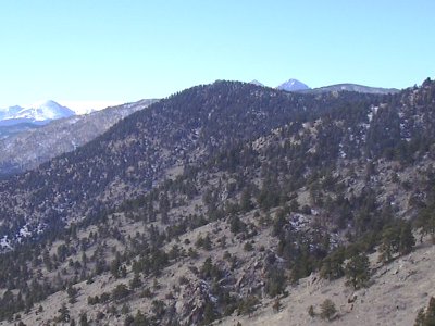
Moose Mtn from Round Mtn, 01/02/09
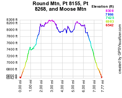
Elevation versus distance, 01/02/09
Round Mountain (7,451 ft), Point 8155, Point 8268, and Moose Mountain (8,075 ft) are Larimer County peaks on the north side of Pinewood Springs. They all lie on the same horseshoe shaped ridge. Moose Mtn is visible from Pinewood Springs, and there is a particularly nice view of it from the intersection of US Hwy 36 and Larimer Cnty Road 118 (road to Big Elk Meadows). It is just across Muggins Gulch (Hwy 36), from Kenny Mountain.
You can see the GPS tracks for this entire hike.
From Lyons, we headed to Pinewood Springs on Hwy 36, and turned right onto Kiowa Road, just past the large collection of mailboxes. We drove up Kiowa Rd about 1.8 miles to where national forest signs show the road to be on national forest land.
Parking at a pulloff on the side of Kiowa Rd, we started hiking at 11:29, taking a trail from the parking place toward Round Mountain. We reached the Round Mtn summit at 12:01, with the odometer at 1.01 miles. From Round Mtn, you can see Moose Mtn to the west.
After Round Mtn, we soon left the trail and headed up the ridge to Pt 8155. We reached Pt 8155 at 12:37, with the odometer at 2.08 miles. From this summit there is a really nice view of Blue Mtn to the northeast.
From Pt 8155 to Pt 8268 we hiked along the ridge, then came upon a trail, which we followed toward Pt 8268. We reached Pt 8268 at 13:04, with the odometer at 3.15 miles. Pt 8268's summit is very flat and surrounded by trees, with no view, and no cairn or anything else to mark the summit.
From Pt 8268, we continued on the trail we were previously following until it intersected with an old road. We turned right on this road, which we soon discovered was the wrong way. We doubled back to this road-trail intersection and took the road in the other direction. After a short distance, we left the road, heading along the ridge to Moose Mountain. This last section to Moose Mtn has a faint trail that disappears entirely further on.
We reached the Moose summit at 13:45, with the odometer at 4.73 miles. Due to the trees, there's not a great view on the summit, but you can see Kenny Mtn to the west, and RMNP to the northwest.
On the summit there was a register jar with a few loose pages. Luke Plumely and Buster signed it on 07/26/07. The last signing was on Nov 15, 2008 by two dogs(?) Munchkin and Schnapps, along with a couple humans.
Heading back approximately the way we came, we got back to our parking place at 15:49, with the odometer at 8.05 miles.
The total time for this hike was 4 hrs, 20 minutes, with a total elevation gain of about 2,100 feet.
- Richard Hollos and Stefan Hollos
| Place name | Elev [ft] | Accuracy [ft] | Lat/Lon |
|---|---|---|---|
| Parking off Kiowa Road | 6590 | 7 | 40.29248,-105.34292 |
| Round Mtn summit | 7470 | 7 | 40.30093,-105.33559 |
| Point 8155 | 8175 | 7 | 40.30525,-105.34489 |
| Point 8268 | 8302 | 12 | 40.30556,-105.35624 |
| Moose Mtn summit | 8110 | 10 | 40.29483,-105.36336 |