Nugget Hill (8,564 ft) from Rowena, 11/30/2008
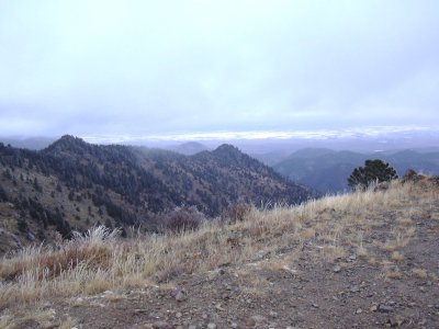
Looking east from Nugget Hill summit, 11/30/08
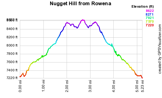
Elevation versus distance, 11/30/08
Nugget Hill is just north of Rowena in Lefthand Canyon, and opposite the canyon from Bighorn Mtn and Butzel Hill. Its summit is bald, and provides great views of the surrounding area. Prominent views from the summit are: the northeast ridge of Nugget Hill, Porphyry Mtn, Bald Mtn, Jamestown, Bighorn and Butzel Mtn, Lee Hill, the Boulder foothills, and the eastern plains.
You can see the GPS tracks for this entire hike.
Driving up Lefthand Canyon 9.1 miles from Hwy 36, we parked just off the road on the west side of Rowena at the beginning of a 4WD forest road.
We started hiking at 12:12, taking the 4WD road up the south side of Nugget Hill. The road climbs steeply up the ridge to a saddle on the ridge. We reached the saddle at 12:58, with the odometer at 1.58 miles. At this point we've climbed 1,100 feet.
From the saddle, we turned right, continuing up a 4WD road which goes all the way to the summit. We reached the Nugget Hill summit at 13:28, with the odometer at 2.43 miles. The summit is 1,400 feet above the parking place.
It was a cold cloudy day, with a moist wind, so we didn't stay long on the summit, and returned the way we came.
Getting back to our parking place at 14:57, the odometer read 5.00 miles.
Just uphill at the last bend in the 4WD road before getting back to Lefthand Canyon Road, there is an old grave: Benjamin Brown, 1835-1905, Company H, 5th Iowa Infantry. His wife who died in 1879, and 1 year old kid are also buried there. It must have been a hard life in Lefthand Canyon back then.
- Richard Hollos and Stefan Hollos
| Place name | Elev [ft] | Accuracy [ft] | Lat/Lon |
|---|---|---|---|
| Parking for Nugget Hill | 7203 | 16 | 40.07726,-105.39352 |
| Nugget Hill saddle | 8330 | 15 | 40.08581,-105.39238 |
| Nugget Hill summit | 8617 | 12 | 40.09155,-105.38089 |