Old Baldy (13,038 ft) from Caribou, 09/04/2010
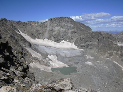
Arapaho Glacier from Old Baldy, 09-04-10
You can see the GPS tracks for this hike.
From Nederland, we took the gravel County Rd 128, and parked at the pass above the ghost mining town of Caribou.
We started hiking at 8:34, taking a gated 4WD road 0.7 miles west, then headed cross country to the top of Klondike Mountain (10,770 ft). Reaching the Klondike summit at 9:25, the odometer showed 1.6 miles. This summit is wooded, and pockmarked with old mining holes.
From the Klondike summit, we headed northwest, descending to a saddle, then climbing steeply up a ridge along a trail. We followed this trail as it eventually faded out on the tundra, heading west to Old Baldy.
Before reaching Old Baldy, we hit the Arapaho Glacier Trail, which we followed for awhile, but left it to ascend the Old Baldy summit. Reached summit of Old Baldy at 11:36 with the odometer at 5.0 miles.
From the Old Baldy summit, the view of Arapaho Glacier is spectacular.
For the return, we headed east to the Caribou benchmark (12,310 ft), getting there at 13:06 with the odometer at 6.7 miles, then turned south, returning on the opposite side of the ridge of our incoming track.
At treeline, we bushwacked for about 0.4 mile through forest until we hit a 4WD road, which we took back to our parking place.
We finished the hike at 15:41, with the odometer at 10.5 miles.
- Richard Hollos and Stefan Hollos
| Place name | Elev [ft] | Accuracy [ft] | Lat/Lon |
|---|---|---|---|
| Parking at Caribou | 10044 | 16 | 39.98095,-105.57885 |
| Klondike summit | 10776 | 16 | 39.97891,-105.60344 |
| Old Baldy | 13057 | 20 | 40.01712,-105.63781 |
| Nearest knob east of Old Baldy | 12813 | 16 | 40.01505,-105.62372 |
| Caribou benchmark point | 12362 | 20 | 40.01435,-105.61037 |