Palisade Mountain (8,264 ft) from Hwy 34, 02/07/2009
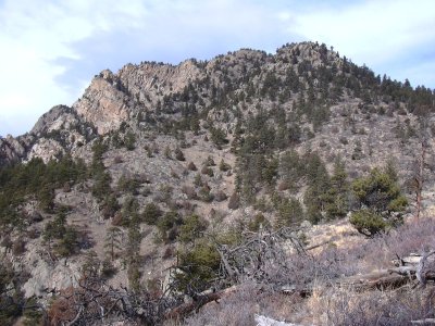
Palisade Mountain from east, 02/07/09
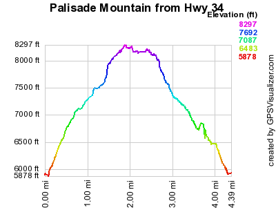
Elevation versus distance, 02/07/09
Palisade Mountain is a prominent peak visible from US Hwy 34 between Loveland and Estes Park. Its most prominent feature, the south face, visible from the highway, has lots of vertical walls.
Thanks to Luke Plumely for suggesting our route.
You can see the GPS tracks for this entire hike.
From Loveland, we headed up the Big Thompson Canyon on US Hwy 34, and parked on the south side of the highway, just past the Big Thompson Indian Village, and the intersection with Idlewild Lane.
Starting at 10:19, we hiked 400 ft east on the road, then north, up a gully. There was some loose barbed wire at the start of the gully that we had to be careful to avoid.
We headed north, ascending the steep rugged slope up toward the east ridge of Palisade Mountain. On the way up, we met a couple bighorns, and got a nice view of the Palisade Mtn summit area. On reaching the ridge, we headed east, up toward the summit.
We reached the Palisade Mtn summit at 11:46 with the odometer at 1.99 miles. West of the summit rock, is a register, composed of a spiral notebook inside a giant PVC tube. The register was put there on March 7, 2008 by a guy named Jim (no last name given). The last signing was Nov 28, 2008. The views from the summit area are wonderful. The Mummy Range, Longs Peak, Cedar Park, Round Mountain and part of Hwy 34 can be seen. Also inside the summit tube are pictures from the summit, with features labeled.
After having lunch near the summit, we explored the summit area. The south side of the mountain, packed with cliffs, has great views of the Big Thompson Canyon and Hwy 34. We returned the way we came, getting back at 14:26, with the odometer at 4.32 miles.
The total time for this hike was 4 hrs 7 minutes, with a total elevation gain of about 2,400 feet.
- Richard Hollos and Stefan Hollos
| Place name | Elev [ft] | Accuracy [ft] | Lat/Lon |
|---|---|---|---|
| Parking off Hwy 34 | 5899 | 7 | 40.42659,-105.30290 |
| Palisade Mtn summit | 8288 | 7 | 40.44028,-105.31062 |