Point 8826 (Jacks Peak), 04/11/2009
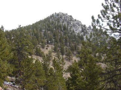
Point 8826 from south ridge, 04/11/09
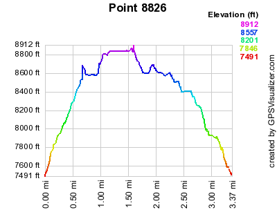
Elevation versus distance, 04/11/09
Point 8826 is on the north rim of Coal Creek Canyon, in Asel Open Space Park. Thanks to Luke Plumely for informing us that this mountain is also known as Jacks Peak. It is northwest of Crescent Mountain, and southeast of Scar Top Mountain.
You can see the GPS tracks for this entire hike.
Parking in Coal Creek Canyon, off CO Hwy 72, at an elevation of 7,500 ft, where Asel Open Space Park meets the road, we started hiking at 9:22. Ascending the steep slope of the southwest ridge, and then north on the south ridge we ascended the knob that is just west of Point 8826. From there we descended to the saddle, then up to the summit of Point 8826. This is rugged country, taking us about 1 hour to travel the 1.1 mile to the summit.
We reached the summit of 8826 at 10:19. There was an old register, but the plastic top of the jar was broken, and apparently a mouse had eaten around the edges of the paper. The last entry was Jan 1, 2009. There are great views from the summit, including Crescent Mtn, Eldorado Mtn, South Boulder Peak, Scar Top Mtn, and Blue Mtn.
Deciding against heading over to Crescent Mtn, because the snow looked deep enough to make it unpleasant, we headed back roughly the way we came, returning at 12:10, with the odometer at 3.01 miles. The total elevation gain was about 1,500 feet.
- Richard Hollos and Stefan Hollos
| Place name | Elev [ft] | Accuracy [ft] | Lat/Lon |
|---|---|---|---|
| Parking off CO Hwy 72 | 7512 | 7 | 39.89083,-105.33221 |
| Point 8826 summit | 8840 | 10 | 39.89824,-105.32192 |