Smithy Mountain (7,135 ft), 12/28/2008
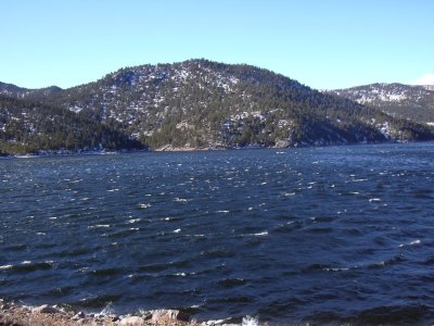
Smithy Mountain from the Dam, 12/28/08
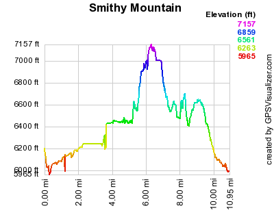
Elevation versus distance, 12/28/08
Smithy Mountain (7,135 ft) is on the south side of Ralph Price Reservoir (aka Button Rock Reservoir), and can be seen from the reservoir's dam. It lies between North St Vrain Creek and Long Gulch. It's east of Cook Mtn and northwest of Coffintop Mountain, and is listed but unranked on Roach's list of Boulder County Peaks.
You can see the GPS tracks for this entire hike.
From the Button Rock Preserve parking area, we started hiking at 10:38, heading up the gravel road, that parallels North St Vrain Creek, to the outlet of the dam. The dam outlet had some amazing ice structures formed where the water shoots out at high velocity.
From the outlet we took the trail that ascends the north side of the dam, then walked across the dam to its south side. On the dam, there was a constant wind that was almost fast enough to blow us off.
On the south side of the dam we took a trail that parallels the shore of Ralph Price Reservoir. Taking this trail until it ends just before Long Gulch, we then came upon a bluff on the east side of the gulch which forced us to climb out of the gulch and head south for awhile before we were able to cross the gulch.
After crossing Long Gulch, we headed west, then northwest to the summit of Smithy Mountain. The terrain from the gulch to the summit was steep, but not too rugged, with a few rock outcroppings which we went around.
We reached the Smithy Mtn summit at 12:47, with the odometer at 5.2 miles. There was no register, nor cairn, on the summit. Because of the trees, the view isn't very nice on the summit, but just to its south is a great view of the dam.
We returned approximately the way we came until the last gulch before the dam. At that point, we left the trail heading east, then northeast, reaching the Sleep Lion Trail just past the next gulch. We then took the Sleep Lion Trail back to its intersection with the North St Vrain Creek and the gravel road.
Returning at 15:33, the odometer showed 9.5 miles. This hike took 4 hrs, 55 minutes, with a total elevation gain of about 1,400 feet.
- Richard Hollos and Stefan Hollos
| Place name | Elev [ft] | Accuracy [ft] | Lat/Lon |
|---|---|---|---|
| Parking at Button Rock Preserve | 6183 | 25 | 40.22838,-105.34132 |
| Smithy Mountain summit | 7132 | 19 | 40.21327,-105.38126 |